


WESTFIELD TWP, Morrow County, Ohio
About
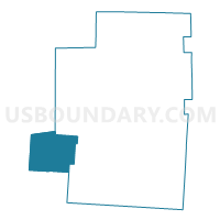
Outline

Summary
| Unique Area Identifier | 650709 |
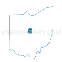
| Name | WESTFIELD TWP |
| County | Morrow County |
| State | Ohio |
| Area (square miles) | 27.01 |
| Land Area (square miles) | 26.99 |
| Water Area (square miles) | 0.02 |
| % of Land Area | 99.91 |
| % of Water Area | 0.09 |
| Latitude of the Internal Point | 40.45182080 |
| Longtitude of the Internal Point | -82.97724880 |
Maps

Graphs
Select a template below for downloading or customizing gragh for WESTFIELD TWP, Morrow County, Ohio


Neighbors
Neighoring Voting District (by Name) Neighboring Voting District on the Map
- ASHLEY VLG A Voting District, Delaware County, OH
- CARDINGTON TWP, Morrow County, OH
- LINCOLN TWP W, Morrow County, OH
- MARLBORO TWP Voting District, Delaware County, OH
- OXFORD TWP Voting District, Delaware County, OH
- PERU TWP, Morrow County, OH
- PRECINCT RICHLAND TWP A, Marion County, OH
- PRECINCT RICHLAND TWP C, Marion County, OH
- PRECINCT WALDO TWP, Marion County, OH
Top 10 Neighboring County Subdivision (by Population) Neighboring County Subdivision on the Map
- Cardington township, Morrow County, OH (3,095)
- Lincoln township, Morrow County, OH (2,063)
- Richland township, Marion County, OH (1,635)
- Peru township, Morrow County, OH (1,513)
- Ashley village, Delaware County, OH (1,330)
- Westfield township, Morrow County, OH (1,177)
- Waldo township, Marion County, OH (1,143)
- Oxford township, Delaware County, OH (987)
- Marlboro township, Delaware County, OH (281)
Top 10 Neighboring Place (by Population) Neighboring Place on the Map
Top 10 Neighboring Unified School District (by Population) Neighboring Unified School District on the Map
- River Valley Local School District, OH (16,332)
- Buckeye Valley Local School District, OH (16,331)
- Cardington-Lincoln Local School District, OH (6,522)
Top 10 Neighboring State Legislative District Lower Chamber (by Population) Neighboring State Legislative District Lower Chamber on the Map
- State House District 2, OH (174,214)
- State House District 90, OH (126,807)
- State House District 83, OH (119,433)
Top 10 Neighboring State Legislative District Upper Chamber (by Population) Neighboring State Legislative District Upper Chamber on the Map
Top 10 Neighboring 111th Congressional District (by Population) Neighboring 111th Congressional District on the Map
Top 10 Neighboring Census Tract (by Population) Neighboring Census Tract on the Map
- Census Tract 9655, Morrow County, OH (6,367)
- Census Tract 9653, Morrow County, OH (6,321)
- Census Tract 105, Marion County, OH (5,244)
- Census Tract 112, Delaware County, OH (3,276)
- Census Tract 111.01, Delaware County, OH (2,897)